Don't tell anyone - in case they want to come around and steal my car - but I've just won a Sat Nav system! (Handy hint - only enter competitions with good prizes but a likely low number of entrants. Focus your efforts.)
The good thing is there's a choice - either a TomTom One GB or a Navman F20.
 Doesn't seem to be much in it - both devices now seem to have decent street level maps of Northern Ireland.
But is there anything else I should be looking out for? Any usability tips from readers who have already played with the devices? Auto-replanning for wrong turns? What's with the Bluetooth of the TomTom One? Problems fitting them into Minis?
Despite being a gadget freak, I've long held off looking at GPSs since there's not much need for them in NI! But a free one could be useful for those random trips in hire cars from mainland airports to far flung offices and hard-to-find hotels. And for finding that short cut through Dee Street to the Odyssey.
December Update: Since it's Christmas, lots of people are googling for TomTom vs Navman and hitting this post. Yet it doesn't really answer the question in the post's title. So some further ramblings may help ...
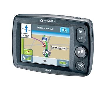
The Navman F20 is being heavily promoted, but there are two aspects I dislike. Most importantly, it doesn't have good maps for Northern Ireland. Get a Garmin or a TomTom One Europe for good all-island Ireland maps. Secondly, as the salesman on Tottenham Court Road demonstrated, the usability is really poor too.
The Garmin units are pricey, but very easy to use. If you can afford one, I'd recommend them. The TomTom One's are cheaper - I got a TomTom One Europe in the end - and you get used to the idiosyncrasies in the interface after a while.
Hope this helps.
6 comments:
TomTom One seems to use a different map set which is solid for the British Isles.
Some GPS units suffer something I call "GPS spiral". It's a frustating condition which can be described as follows. Approaching your destination the GPS identifies an exit but it's not very clear about it so naturally you miss the exit. Not a problem I hear you cry the GPS will work out where to go next. That however is where is all goes wrong. In GPS spiral, the unit works out the next move and tells you where you are going just after the turn that it was about to recommend. Thus you miss that exit too and in exteme cases orbit your destination in a helpless fashion. If your unit requires any human intervention to recompute (some very badly designed ones do) then your orbit will be even more erratic.
Unfortunately I can't offer an opinion between your two specific choices. The best thing would be to try them out.
So the moral of this story is that you should really see how the various choices handle the error condition. Isn't that what 90% of all programming is about?
A couple of other thoughts spring to mind while driving today. Some units have a safety feature which effectively means that you cannot change the destination details whilst on the move. This is annoying and especially frustrating if you have a passenger who can operate the unit. Built-in units like the OEM ones in Toyotas have no way to disable this feature. I do know that you can turn it off with most Garmin units.
And as for finding that elusive shortcut through Dee Street to the Odyssey. Well in the magical world of GPS be warned. The route it chooses is not always what you would like or expect. Do not trust the GPS blindly, it can lead you astray.
Forcing the GPS to re-compute the trip as you proceed is a very useful thing to do. Many units compute once and only re-compute if you stray from the path.
Sometimes when you re-compute the unit can find that elusive "Northwest Passage".
The "killer app" for GPS is to be able to automatically take account of local road conditions and then find you somewhere to park.
I would definitely go with the ONE-- I borrowed my friends the other weekend and was so impressed with the easy to use features and the various routes it would give you to avoid traffic, etc. I know that TT is the #1 provider in the UK as well so that shows something.
I should have posted back a resolution before now. But in case anyone stumbles across this posting while Googling for an answer ...
If you're in Northern Ireland, but a Garmin, or a TomRom One EUROPE. Both use Navteq maps which include detailed maps of NI roads (in fact, Ireland - north and south). (The TomTom One UK/GB maps are not Navteq.)
I got a TomTom One Europe and it works well. Must compile a list of map corrections though - but that would be the case across the UK. It's not perfect. But it's faster than a map on your lap.
i recently purchased a garmin nuvi 250w. i was told it was the best system for northern ireland by a few lorry drivers and delivery people. its been great so far but as with all new gismos unless theyre kept up-to-date, theyre useless. its relatively easy with garmin, which have sd card slots in them available every month or so to upload new road layouts and construction areas.
Post a Comment